Route planning meets trail nutrition

Plan the miles.
Pack the fuel.

Turn your route into daily calorie targets and a food pack that fits the trip. Plan your stops, see what each day demands, and choose your meals in one app.

Free download · 7-day free trial · Paid subscription after trial

Terrain-aware estimates680,000+ foodsBarcode scanning
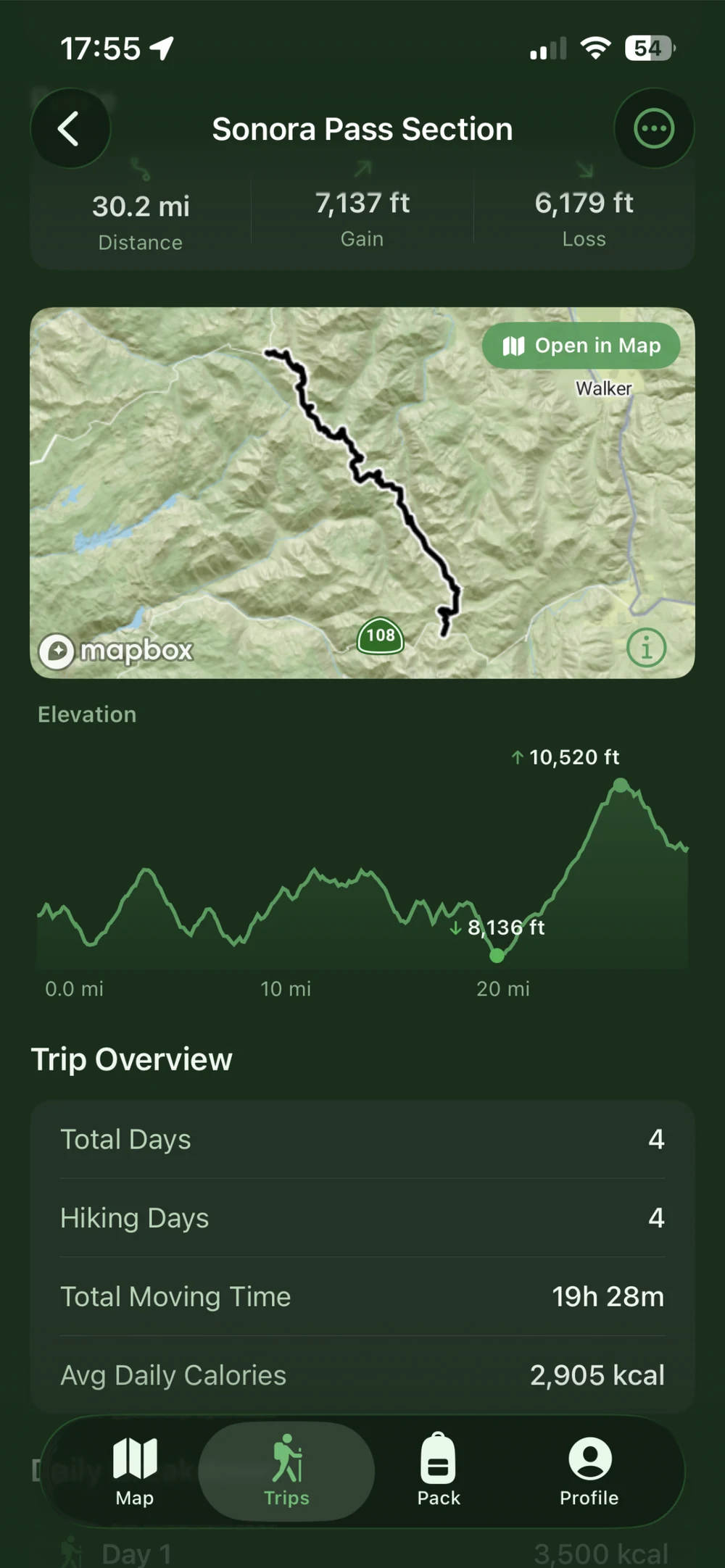
Sonora Pass trip overview showing a 30.2-mile route map, elevation profile, four hiking days, moving time, and average daily calorie estimate.

One connected plan

From the first waypoint to the last trail snack.

Your route tells you what the trip asks of you. Your food plan helps you prepare for it.

01 / Plan the route

Build the trip around your kind of adventure.

Draw a route on 3D terrain maps or bring in a GPX file. Mark camps, water sources, and resupply stops, then shape the route as your plans take form.

  • Follow trails with snap-to-trail routing or draw freely
  • Move waypoints and add points along an existing route
  • Mark overnight stops to split your trip into hiking days
  • See your saved trips on the map and tap to keep planning

Your route, camps, and resupply stops belong in the same plan.
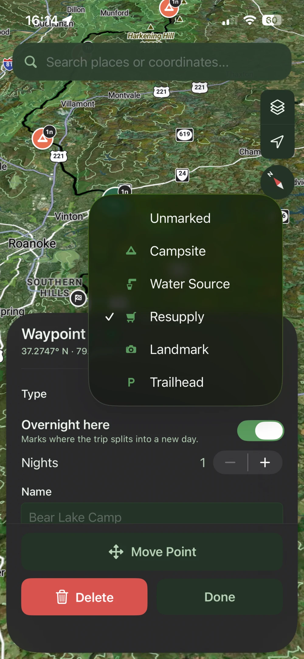
Waypoint type selector with campsite, water source, resupply, landmark, and trailhead options, plus overnight-stop and move-point controls.

02 / Find your fuel needs

A different day deserves a different calorie target.

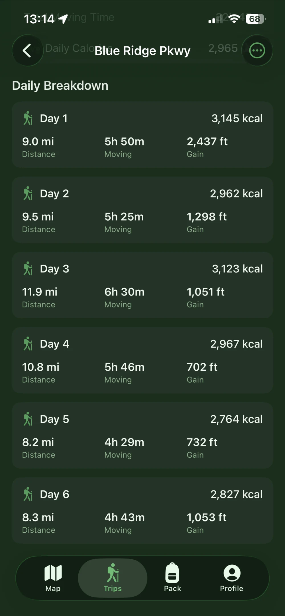
A long climb and a short valley day ask different things of your body. Get calorie estimates based on your route, pack weight, pace, and personal profile, with the details for each day in one place.

  • See daily calories, mileage, elevation gain, and moving time
  • Account for the energy cost of carrying your pack
  • Use terrain and grade to inform your calorie estimates
  • Review the elevation profile and the trip as a whole

Built on peer-reviewed research into the energy cost of loaded hiking.

See how the estimates work
Blue Ridge Parkway daily plan showing six hiking days with individual calorie estimates, distance, moving time, and elevation gain.

03 / Build your food pack

Turn your calorie target into food you want to eat.

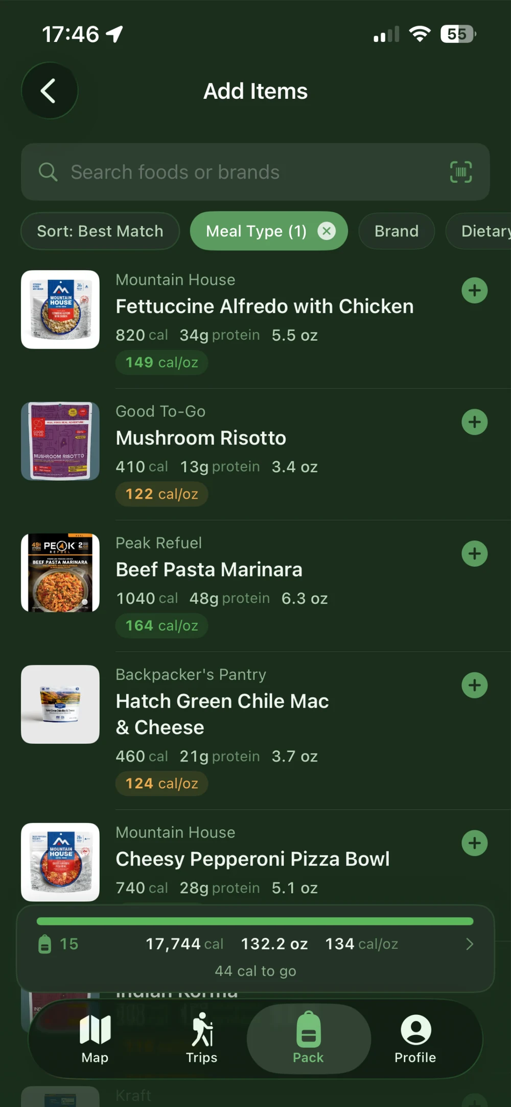
Search 680,000+ foods, from backcountry meals to grocery-store favorites. Scan a barcode to look up a food, compare calories per ounce, and watch your pack take shape as you add items.

  • Browse food photos and nutrition details before adding
  • Narrow your search by meal type, brand, and dietary preferences
  • Track calories, protein, carbs, fat, and total food weight
  • See your progress toward the trip calorie target as you pack

Less time building spreadsheets. More time looking forward to dinner.

Food catalog with trail meal photos, calories, protein, food weight, calories per ounce, dietary filters, barcode search, and progress toward a calorie target.

See more of the terrain

More context. Better preparation.

Switch map layers to understand the landscape around your route.

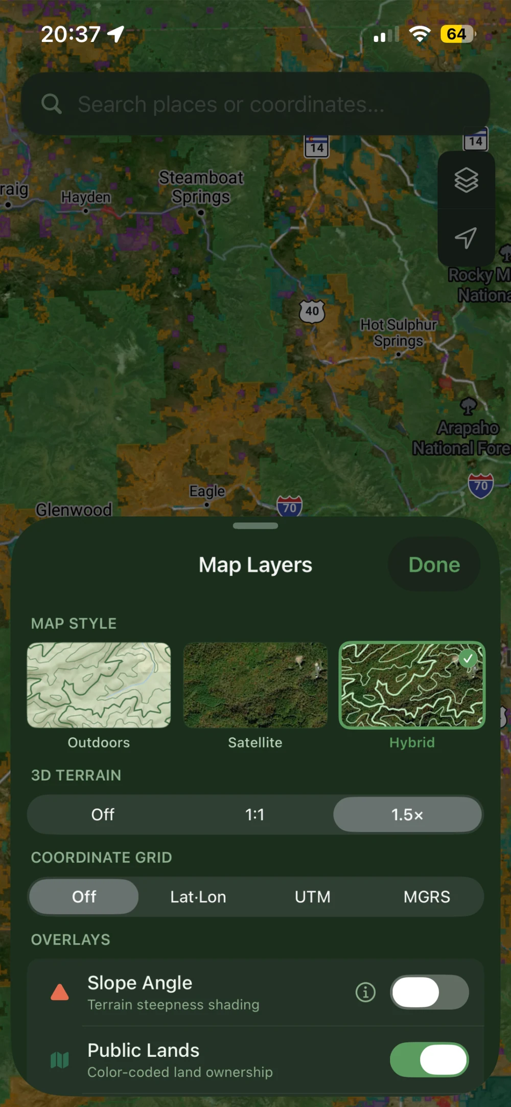
Public-land boundaries

See land ownership alongside your route as you explore trailheads, camps, and the places in between.

Slope-angle shading

Read the steepness of the terrain with color-coded slope bands across the contiguous United States.

Active wildfire perimeters

Bring reported fire boundaries into your map view for more context while you plan.

Layer coverage and freshness vary. Check official fire alerts and local access rules before heading out; map overlays do not replace current conditions or an avalanche forecast.

Map Layers panel with Outdoors, Satellite, and Hybrid styles, 3D terrain, coordinate grids, and slope-angle and public-land controls over a Colorado map.

Research behind every estimate

Your body. Your pack. Your terrain.

Carrying a loaded pack changes the work of hiking. MTNMetrics uses the LCDA model from peer-reviewed U.S. Army research to help estimate that effort and turn it into a practical food plan.

Read the research

Weekend backpackers

Build a food plan for your next overnight without starting a spreadsheet.

Thru-hikers

Plan food for each section and mark the resupply stops along the way.

Ultralight hikers

Compare calories per ounce and see what each food adds to your pack.

Backcountry hunters

Factor heavy loads and demanding terrain into your calorie estimates.

Before you hit the trail.

What does the subscription include?

Your subscription brings route planning, GPX import, saved trips, personalized calorie estimates, and the food pack builder together. Search the food catalog, scan barcodes, and track nutrition and food weight against your trip target.

Is MTNMetrics free?

MTNMetrics is free to download and offers a 7-day free trial. After the trial, a paid subscription is required to continue using the app. There is no ongoing free app tier. See the in-app subscription screen for current pricing, trial eligibility, and renewal terms.

Can I use a route I planned somewhere else?

Yes. Import a GPX file into MTNMetrics, then use your route to plan hiking days and estimate calorie needs. You can also draw a route directly on the map with snap-to-trail or freehand routing.

How are my calorie needs calculated?

MTNMetrics uses the LCDA model from peer-reviewed research on loaded hiking, together with your personal profile, pack weight, pace, terrain, and elevation. The results are estimates for planning; your needs can vary with conditions and effort.

Where are the map layers available?

Available layers include public-land boundaries, slope-angle shading, and active wildfire perimeters. Coverage varies by layer; slope-angle shading covers the contiguous United States. Fire data can lag conditions, so check current official alerts when planning.

Which devices are supported?

MTNMetrics is available for iPhone running iOS 17 or later. You can use the free hiking calorie calculator on this website from other devices.

Want a quick starting point? Try the free hiking calorie calculator.

Make your next trip a well-fed one

Your next adventure starts with a plan.

Map the route. Set daily calorie targets. Search or scan the foods you love and build your pack with MTNMetrics.

Free to download for iPhone. Start with a 7-day free trial.

A paid subscription is required after the trial. Trial eligibility and terms apply. iOS 17 or later.